
Greensboro ZIP Code Directory Coverage
This Greensboro ZIP code directory starts with the city-associated codes found in the official Guilford tax city-name table. The table is useful for a local records search, but it is not a USPS delivery map and does not establish a ZIP’s facility, street-delivery status, or neighborhood boundary. Local planning sources use broad labels for a few areas, while many table codes need an address-specific USPS result before a street search is attempted.
| Greensboro ZIP | Area label supported by research | Post office or type | Records-use note |
|---|---|---|---|
| 27401 | Central or downtown Greensboro label | USPS designation not individually verified | Check street and PO mix by address. |
| 27402 | Greensboro tax-table code | Facility or type not located | Do not assume ordinary street delivery. |
| 27403 | Greensboro label in the city report | USPS designation not individually verified | Verify address and municipal geography. |
| 27404 | Greensboro tax-table code | Facility or type not located | Tax-table reference only. |
| 27405 | Broad northeast Greensboro label | Greensboro area, facility not individually verified | Use parcel and map layers for the boundary. |
| 27406 | South Greensboro label | Greensboro area, facility not individually verified | Only partly within city limits. |
| 27407, 27408, 27409 | Greensboro-area labels in local materials | Facilities not individually verified | Check each address; ZIP is not a neighborhood line. |
| 27410 | Broad northwest Greensboro label | Greensboro area, facility not individually verified | Use GIS for city and subdivision geography. |
| 27411, 27412, 27413 | Greensboro tax-table codes | Facility or type not located | Confirm before treating as street-delivery codes. |
| 27455 | Broad north Greensboro label | Greensboro area, facility not individually verified | Useful area label, not city-limit proof. |
| 27495, 27497, 27498, 27499 | Greensboro tax-table codes | Facility or type not located | Specialized or unique use is possible; USPS confirmation is required. |
Adjacent Guilford postal labels such as 27301 for McLeansville and 27214 for Browns Summit appear in historical Greensboro-area material, but they are not automatically Greensboro city labels. The same caution applies to High Point, Jamestown, Oak Ridge, Pleasant Garden, Stokesdale, Summerfield, Whitsett, and other surrounding community labels.
Verify a Greensboro ZIP Code by Address
Use the USPS ZIP Lookup for a particular residential or business street address, city, and state. That exact-form result is the authoritative ZIP step in a Greensboro postal workflow. The research did not capture a prefilled Greensboro result, so it does not assign a delivery type or station to codes where the official source did not verify one.
After USPS confirms the mailing ZIP, compare the parcel in Guilford’s property and GIS tools. A postal result answers delivery geography. It does not answer city jurisdiction, tax jurisdiction, election district, police service, or which agency holds a municipal record. Those answers need the parcel’s city and planning fields, the city-limit map, or an election map.
For a historical or unusual address, preserve the USPS result alongside the street spelling that appears in the source record. Greensboro’s current address label may differ from an older directory corner description or from a legal description in a deed. A verified mailing ZIP should clarify a present address, not replace the wording used in an older record.
Greensboro Parcel Research by ZIP
Guilford Parcel Research is the county’s documented ZIP-capable property route. It uses a SQL-style workflow: select an operator, select a search category, add the criteria, and perform the search. The display is capped at 150 records, while the full result set can be exported to CSV. The county warns that the tax-system data changes daily and is supplied without warranties, so save the search date with any result.
| Parcel Research field | What it contributes to a ZIP search |
|---|---|
| PHYADDR_ZIP | Physical-address ZIP field used to filter matching parcels. |
| PROPERTY_OWNER | Owner field for a parcel-level cross-check after the ZIP filter. |
| ZONING and ETJ | Land-use and extraterritorial-jurisdiction context that a postal code cannot supply. |
| Total assessed-value fields | Parcel valuation context, not a measure of who is present at an address. |
| CSV export | Full result-set export after a query; the on-screen result display has a 150-record ceiling. |
The Guilford Parcel Research interface is the source for this ZIP-filter path.
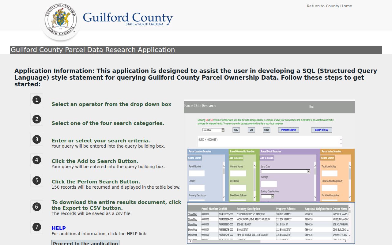
Parcel Research is useful because it carries the physical-address ZIP field alongside property geography. It is not a household directory, and the basic NCPTS landing search did not expose ZIP as one of its three primary choices.
The county’s property data disclaimer also matters here. A daily-changing tax-system result can be a valuable pointer to a parcel, but the official records and any needed correction route remain with the relevant county office. Use the export for a defined geographic question and return to a card, map, or custodian when one record needs closer review.
Find Greensboro Records by ZIP
A ZIP code narrows parcel research, but it should not be used as a claim that every person in the area appears in one result. The county property route returns parcel data. The public state voter search uses a person’s first and last name with status selection and offers a county filter, not public ZIP-wide browsing. The election map is for precinct and district geography, not a name roster.
- Confirm the exact address through USPS before selecting a Greensboro ZIP.
- Query Parcel Research with PHYADDR_ZIP and record the returned parcel identifiers, not just the displayed address.
- Open a matching parcel through NCPTS or the Area Plan Viewer to compare city, planning, and legal-description fields.
- If a lawful civic record request is needed, describe the geography and fields precisely to the Guilford Board of Elections. Its research notes a typical 7 to 10 business day turnaround for reports, data, and maps, not a promise of a ZIP-wide personal list.
- Once one address is confirmed, use the Greensboro street directory for the address-by-address record chain.
Note: ZIP filtering is a geographic starting point, not a substitute for matching the parcel, person, or historical address record.
Greensboro ZIP Code Tools Have Separate Uses
Greensboro’s local tools are deliberately uneven. Parcel Research exposes PHYADDR_ZIP and export options. NCPTS is the property-card route for owner, mailing, situs, deed, and value fields. The Area Plan Viewer searches by REID or address rather than ZIP, then adds planning layers. The city geocoder can accept a ZIP as part of address matching, but it is a geocoder, not a resident list. The voter search has county and year filters, while the election map answers precinct and district questions.
Guilford’s Area Plan Viewer provides the documented address and REID map route after a ZIP query identifies a particular parcel. Moving among these tools is normal because no single portal answers postal, parcel, planning, and civic questions at once.
For a defined county question, Parcel Research can filter the physical-address field and export the matching result set. For one selected property, NCPTS supplies the detailed card. For address geometry, use a map viewer. Keeping those functions separate avoids treating a postal filter as a definitive city-boundary or personal-record result.
Greensboro ZIP Boundaries and City Limits
Postal delivery and service areas are not legal municipal boundaries. The most useful Greensboro example is 27406: local planning material calls it South Greensboro, yet only part of that ZIP lies inside the city limits. Broad labels also describe 27405 as northeast, 27410 as northwest, and 27455 as north Greensboro. Those labels help orient a search but do not establish the city jurisdiction of a given parcel.
Use city and county maps to resolve the mismatch. Guilford GIS handles addressing in unincorporated county areas and several towns, while Greensboro and High Point handle their own road signs. The city tracks annexations, street changes, and map PDFs. A current parcel’s city or planning field is more reliable for records routing than a postal designation alone.
Guilford GIS Addressing is at 400 W. Market Street, Greensboro, NC 27402, and lists 336-641-2337, also shown as 641-ADDR, for addressing questions. It manages the countywide Master Road Name database with municipalities, Emergency Services, Guilford Metro 9-1-1, and developers. That local split is why a postal label, a road sign, and a county address record can serve different purposes.
- ZIP and ZIP+4
- A ZIP identifies a broader postal service area; ZIP+4 adds a more specific delivery segment and must be confirmed for the exact address.
- PO-box ZIP
- A code used for post-office-box service. A tax-table appearance does not confirm that a code has this status.
- Unique ZIP
- A code that may serve a particular institution or specialized delivery use. The Greensboro tax list alone does not verify which codes are unique.
- Carrier route
- A postal delivery grouping below the ZIP level. It is not a municipal boundary or a public list of people.
Greensboro Postal History Has Limits
Modern postal codes are not the right key for every older Greensboro address. Historical city directories may use a street corner, a neighborhood label, a rural route, or an abbreviation. Deeds can rely on a legal description, plat, acreage, or adjoining tracts. Greensboro’s address and annexation history can also leave a past record under a street spelling or jurisdiction that differs from today’s address.
For an older address, keep both forms in the research notes: the historical wording and the current standardized address. Reverse city directories, Sanborn maps, the deed legal description, and street-change tracking provide the bridge. This Greensboro reference is a current-geography tool, not a way to rewrite older records into a modern postal label.
When those sources disagree, retain the source date and its original address wording before deciding that two records describe the same place.